Outback Graves Markers
Outback Graves Markers
Region: Goldfields-Esperance
Coordinates: -29.82038, 120.520278
Directions:
Shire Menzies
Located About 60kms west of Menzies and 160kms north of Coolgardie
Reserve Number R7816
Number of Graves: 33
First Burial: John Grogan buried 1 March 1899. He was a 50-year-old miner who died after a fall down a mine shaft at British Lion Lease
Last Burial: Andrew John Evans buried 17 March 1925. He was a 63-year-old miner who died of pneumonia and heart failure
History
Name
The name Mulline is Aboriginal in origin (meaning unknown) and was used to refer to the nearby Mulline Rock. It was first recorded by the Surveyor Brazier in 1894.
Discovery
Gold was discovered in 1891 by James Speakman, Chas Erickson and Larry Ryan, funded by a Southern Cross syndicate, making it one of the earliest finds in the Goldfields, predating the Coolgardie rush by a year. Their find was named Off Chance Mine, near Ularring Rocks at the southern end of the field. Ularring Rocks were named in 1875 by Ernest Giles, who is believed to have blazed a tree in the area. Speakman later pegged another lease called Speakman’s find at Mt Callion.
Early History
The townsite of Mulline was gazetted in 1897. The field is a 2 km wide and 15 km long stretch of workings from north to south to the west of the Davyhurst-Mulline Road. Because of its remoteness, miners struggled on the field until a ten-head state battery was built in 1898. Even after that there were difficulties with the contractor going into liquidation. The battery was not fully operational until about 1900. Prior to that quartz was sent to Menzies for crushing. The main mine was the Lady Gladys which crushed one to two ounces to the ton until 1911 when the yields declined. There were also many small workings.
By 1900, Mulline had two hotels and several businesses and, because of the erection of the battery, it became the main centre for the miners of the Ularring area to the south and Riverina leases further north.
Today little remains except for a few signs of building foundations and stone walls and the cemetery.
Statistics
|
AGES AT DEATH |
|||||
|
0 – 1 |
7 |
20 – 29 |
1 |
60 – 69 |
4 |
|
2 – 5 |
2 |
30 – 39 |
3 |
70 – 79 |
2 |
|
6 – 9 |
1 |
40 – 49 |
4 |
80 + |
0 |
|
10 – 19 |
3 |
50 – 59 |
5 |
Unknown |
1 |
|
OCCUPATIONS |
|||||||
|
Battery Hand |
1 |
Child |
11 |
Married Woman |
4 |
Sandalwooder |
1 |
|
Battery Manager |
1 |
Hotel Keeper |
1 |
Miner |
7 |
Unknown |
2 |
|
Carpenter |
1 |
Labourer |
2 |
Prospector |
2 |
|
|
|
CAUSE OF DEATH |
|||||||
|
Alcoholic poisoning |
1 |
Gun accident |
1 |
Natural causes |
1 |
Suicide |
1 |
|
Asphyxia |
1 |
Heart disease/failure |
5 |
Pernicious anaemia |
1 |
Tuberculosis |
1 |
|
Broncho Pneumonia |
1 |
Kidney failure |
1 |
Pneumonia/heart failure |
1 |
Whooping cough |
1 |
|
Burns |
1 |
Lost in bush |
1 |
Premature birth |
2 |
|
|
|
Cardiac syncope |
2 |
Marasmus |
3 |
Pulmonary complaint |
1 |
|
|
|
Childbirth |
1 |
Mining accident |
1 |
Septic abscess |
1 |
|
|
|
Fall down mine shaft |
2 |
Murder |
1 |
Septicaemia |
1 |
|
|
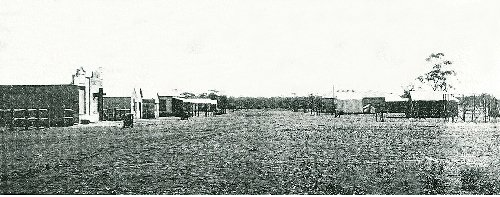
Main street Mulline (Photo from State Library WA)
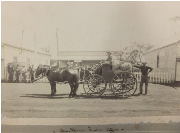
Mulline Post Office (Photo from State Library WA)
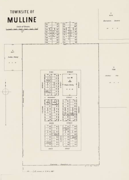
Map of Mulline townsite - courtesy of State Library WA
An early writer described Mulline as a sleepy place, where the most exciting thing to happen through the day was a dog barking.
With very limited rainfall, early miners had to pay 20 shillings per 100 gallons of condensed water.

